A scenic drive becomes a virtual mountain rally at 2.5× speed. Join me for three contrasting stages through the mountains of Kumamoto, Japan—from the gentle landscapes of the Hitoyoshi Basin to winding mountain roads and a dramatic descent toward Misato.
CHAPTERS
00:00 Stage 1 Begins
00:47 One Mountain Route, Three Rally Stages
02:58 Joining National Route 445
06:49 Three Stages, Three Different Landscapes
15:19 Stage 2 Begins: Komoriuta no Sato Itsuki Roadside Station
29:11 Stage 2, Second Half: Into the Narrow Mountain Roads
32:42 Stage 3: The 860 m Descent!
ABOUT THIS DRIVE
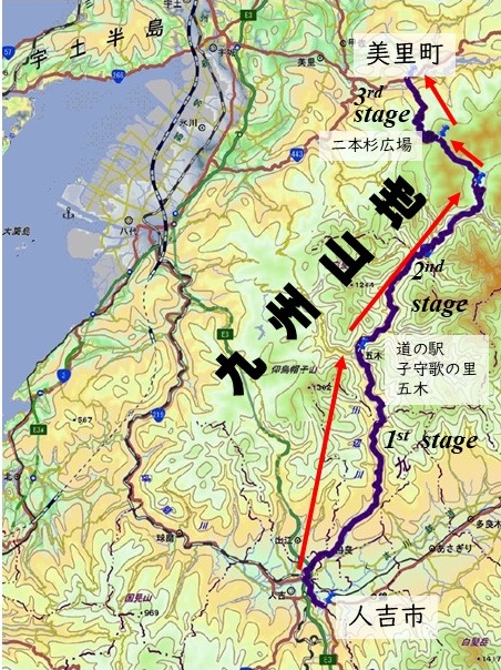
Filmed with an onboard camera, this video follows a journey from Hitoyoshi to Misato, mainly along National Route 445 through the Kyushu Mountains. Much of the southern and central part of the journey follows the Kawabe River, known for its clear waters, before the route climbs toward Nihonsugi Pass and crosses into the northern foothills.
At 2.5× playback speed, the bends, climbs, and changing scenery take on the feel of a mountain rally. The route divides naturally into three stages, each with a distinctive landscape and driving atmosphere.
This is a virtual rally created through accelerated playback of a public-road drive. The apparent speed is an editing effect, and the stage names are used for this video.
THE THREE STAGES
STAGE 1 — From the Basin to the Foothills
The journey begins on the relatively flat floor of the Hitoyoshi Basin, passing through residential areas and rural scenery before entering the foothills of the Kyushu Mountains.
Think of this as the opening touring stage: settle in, enjoy the scenery, and watch the mountains draw closer.
STAGE 2 — Deep into the Kyushu Mountains
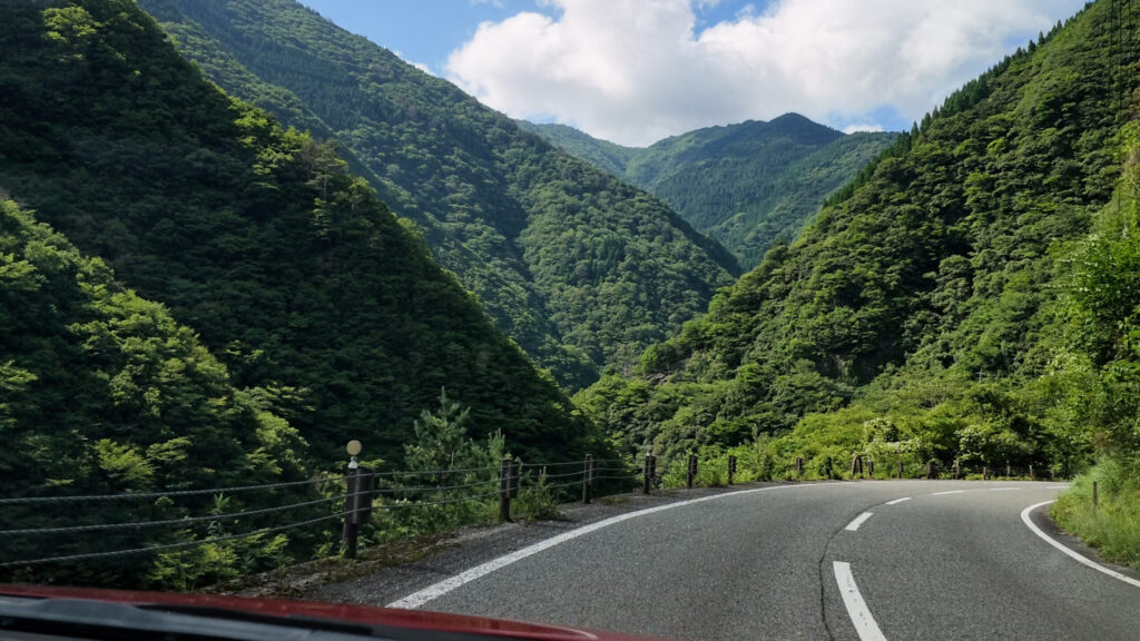
Beginning at Komoriuta no Sato Itsuki roadside station, the second stage heads deeper into the mountains. Sweeping bends give way to tighter turns, changing elevations, and increasingly narrow stretches as the route climbs toward Nihonsugi Pass.
At 2.5× speed, the succession of curves creates the unmistakable rhythm of a mountain rally stage.
STAGE 3 — The Narrow Descent
From Nihonsugi Pass, at approximately 1,100 m above sea level, the final stage descends toward Misato, losing approximately 860 m in elevation.
The road twists down the mountainside through sections so narrow that passing an oncoming vehicle can be difficult. At accelerated playback speed, the descent almost feels like a driving game.
STAGE DISTANCES, ELEVATION CHANGES, AND AVERAGE SLOPES
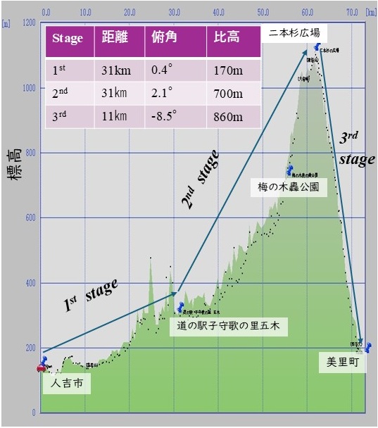
To picture the overall climb or descent, imagine straightening each stage into a single, continuous slope with the same road length and the same elevation difference between its start and finish.
Stage 1 — A Gentle Rise
Approximately 31 km, finishing about 170 m higher than the starting point. This is equivalent to an average uphill angle of just 0.3°—a gentle rise overall, beginning on the relatively flat basin floor and continuing into the foothills.
Stage 2 — The Mountain Climb
Approximately 31 km, finishing about 700 m higher. The equivalent average uphill angle increases to about 1.3°. That may sound modest, but it is an average over the entire winding stage: individual climbs can be considerably steeper.
Stage 3 — The Descent
Approximately 11 km, finishing about 860 m lower. The equivalent average downhill angle is about 4.5°, making this stage much steeper overall than either of the preceding stages. Combined with tight bends and narrow road sections, the descent delivers the strongest sense of a virtual rally.
Total distance: approximately 73 km.
These angles describe each stage’s overall elevation change spread across its full road length. They do not represent the steepness of individual road sections or the surrounding mountainsides, and they do not include cumulative ascent and descent.
THE GEOLOGY BEHIND THE SCENERY
Why does the landscape change so dramatically along this route?
Much of the Kyushu Mountains is underlain by ancient accretionary complexes, part of the broad geological framework also found in Shikoku and the Kii Peninsula. These complexes formed where an oceanic plate descended beneath the overriding plate, scraping off and incorporating sediments and pieces of oceanic crust. Rocks that once lay beneath the sea now form the foundations of these mountains. [1]
Stage 1: Ancient Bedrock, Volcanic Deposits, and River Terraces
The mountain bedrock in the southern part of the route belongs largely to the Cretaceous accretionary complexes of the Shimanto Belt.
Around the Hitoyoshi Basin and adjoining foothills, this older bedrock is locally covered by younger deposits. These include Quaternary pyroclastic-flow deposits, including material from the Kakuto caldera, as well as river deposits and terraces associated with the Kawabe River and the wider Kuma River system. The gentler scenery reflects both this younger cover and the basin’s history of deposition and erosion. [1]
Stages 2 and 3: Crossing Older Geological Belts
The transition from Stage 1 to Stage 2 is interpreted here as broadly corresponding to the vicinity of the Butsuzo Tectonic Line, a major geological boundary separating the Shimanto Belt to the south from the Chichibu Belt to the north. Regional surveys document this boundary in the Kawabe River area. [2]
Farther north, the route crosses older accretionary rocks, including Jurassic complexes, together with other geological units within a complicated arrangement of faults and folds. These structures help explain the changing character of the mountain landscape. [1]
The northern descent also approaches the region traversed by the Usuki–Yatsushiro Tectonic Line. This is another important regional geological boundary, although the steep terrain cannot be attributed to this structure alone. [3]
The scenery is the combined result of geological structure, differences in rock resistance, uplift, and prolonged erosion by rivers and hillslope processes.
A ROAD SHAPED BY DEEP TIME
The road is human-made, but the landscape that gives this virtual rally its character has developed over millions of years.
As the bends unfold, imagine the history beneath the wheels: ancient seafloors, accretion and faulting, volcanic deposits, and rivers cutting deeper into the mountains.
Enjoy the virtual rally—and the geological story along the way.
FILMING DATE AND ROAD CONDITIONS
Filmed on June 28, 2026.
As of October 18, 2026, the Nihonsugi–Hagi section of Route 445 is listed as closed because of rockfall. This footage records conditions before that closure. Please check the latest official road information before planning a visit. [4]
For now, enjoy the journey virtually. Once the road reopens, take your time and experience the scenery at its natural pace.
SOURCES AND FURTHER INFORMATION
[1] Geological Survey of Japan, AIST. Geological Map of Japan 1:200,000, “Yatsushiro and a Part of Nomo Zaki.”
https://www.gsj.jp/data/200KGM/PDF/GSJ_MAP_G200_NI5212_2010_D.pdf
[2] Ministry of Land, Infrastructure, Transport and Tourism, Kyushu Regional Development Bureau. Kawabe River geological survey material (in Japanese).
https://www.qsr.mlit.go.jp/kawabe/wp-content/uploads/sankou105.pdf
[3] Geological Survey of Japan, AIST. Discussion of the Median Tectonic Line and the regional geology of Kyushu (in Japanese).
https://www.gsj.jp/hazards/earthquake/kumamoto2016/kumamoto20160513-2.html
[4] Gokanosho road restriction information (in Japanese; updated October 7, 2026).
https://goka.sakura.ne.jp/goka/kankou/cgi/inf3/inf3.cgi
#VirtualRally #Route445 #JapanDriving #Kyushu #Kumamoto #MountainRoads #DrivingVlog #Geology